
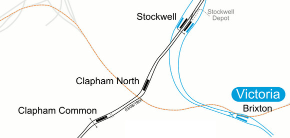
If you’re as cartographically obsessed as me, you’ll quite happily spend long hours poring over Ordnance Survey maps, archive maps, route diagrams and rail maps, and if you’ve any interest in the London Transport network, here’s a great map for you!
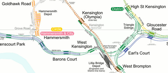
Created by French mapping wizards carto.metro, the map offers a ton of fascinating detail about the capital’s network, letting you peruse track layouts, section opening and closing dates, crossovers, sidings, closed stations, disused lines and platform positions.
You can view the map here – and zoom in and out to your heart’s content – and there’s also a handy downloadable PDF file here.
Related posts:
 A top coffee at Ray’s Jazz Cafe, Foyles bookshop, Charing Cross Road, central London
 Soho’s The Old Cafe set to be booted out of the former Foyles building
 The Old Cafe in Charing Cross, Soho gets booted out on Monday
 Explore the tunnels of London’s Crossrail with this fantastic interactive video
 London Bridge rail redevelopment charges across Borough Market
 Poster Girls – a century of wonderful art and design by female artists at the London Transport Museum
 A fantastic cafe for central London: The Old Cafe takes over Ray’s Jazz in the former Foyles store
 Fabulous rail footage: London to Brighton train ride,1953-2013


If you haven’t got it already, the London Railway Atlas is even better. It shows all mainline tracks and stations, including closed and proposed ones. It has many more zoomed-in areas for complex sites.
http://www.amazon.co.uk/London-Railway-Atlas-Joe-Brown/dp/0711033978
That’s one of the best ‘real’ tube maps I’ve seen, interesting stuff. The Victoria line runs well to the west of where I imagined it.
@XP
This book is interesting but it contains errors and is not up-to-date (of course ;-). I’love the online map, and it’s much more readable !
on the subject of tube maps, there’s a chap in Greenwich market who does a nice line (see what I did there) in alternative tube map prints. I’ve got a big pacman tube map print on my office wall at the mo.
check out the great graphic designed London railway maps from Zero Per Zero, quality is superb, silver overlay, attractions, Over and Underground shown…
http://www.rawdice.co.uk/index.php?rewrite=category&catid=3
That’s great. But agreed with XP the London Railway Atlas is much better.