Action, protest, campaigns, demos and issues magazine features, photos, articles, stories photos of London, New York, Wales, England and photography features music, parties, clubs, events, records, releases drug information, harm reduction, no-nonsense guide punch a celebrity football, features, issues, cardiff city games, useless games and diversions technical info, web authoring, reviews and features site news, updates and urban75 blog urban75 community news and events urban75 bulletin boards join the chatroom search urban75 back to urban75 homepage
London features, photos, history, articles New York features, photos, history, articles Brixton features, photos, history, articles panoramas, 360 degree vistas, London, New York, Wales, England Offline London club night festival reports, photos, features and articles urban75 sitemap and page listing about us, info, FAQs, copyright join our mailing list for updates and news contact urban75
Brixton guide homepage Brixton features Brixton photos Brixton history Brixton bars, clubs and pubs - a guide Brixton restaurants, cafes and greasy spoons Brixton info, useful numbers, resources etc
Brixton Then and Now photos index

Then and Now: Mayall Road towards Herne Hill
Photographic comparisons of old and modern views of Lambeth

Mayall Road by Chaucer Road, Brixton, 1912

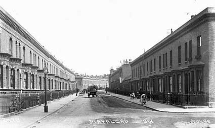
c. 1912 A scene looking south along Mayall Road by Chaucer Road. A coal merchant on a horse drawn goods wagon heads towards Herne Hill while children play on the near-deserted streets. Note the iron railings either side of the street.
(pic: Lambeth Archives)

Mayall Road by Chaucer Road, Brixton, May 2004

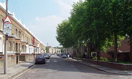
May 2004 The row of houses to the right have disappeared, possibly as a result of WW2 damage. The rest of the street looks much the same, save the usual addition of modern street furniture, speed bumps and parked cars.

Reader update: "As a child I lived in one of the houses with the white bay windows on the left. This was during WW2 and I can confirm that the houses on the other side of the road were destroyed by German bombs. The derelict bomb site became my playground. Later in the war Lambeth Council built 'prefabs' on the site." John Coomber


top


« back to history homepage     next page »

Acre Lane
Atlantic/Railton
Brixton Hill
Brixton Road
Brixton Station Rd
Central Brixton
Coldharbour Lane
Effra Road
Electric Ave/Lane
Herne Hill
Loughboro Junc

ATLANTIC/RAILTON
» Atlantic/Brixton Rd
» Atlantic Rd, 60s
» Atlantic Rd/Pope's
» Atlantic/Pope's
» Atlantic Rd N
» Atlantic Rd S
» 66/68 Atlantic Rd
» 'Alfie', Atlantic Rd
» Atlantic/Vining St
» Barnwell Rd
» Mayall/Chaucer Rd
Mayall/Chaucer (2)
» Railton Rd/Effra
» Railton/Herne Hill

» NEXT PAGE

« Photos listing
« History home

HISTORY SOURCES:
» Reference/info
» Brixton history
» Brixton posters
» Brixton forum

EXTERNAL LINKS:
external link Lambeth Landmark
external link Brixton Society
external link Lambeth Council

post up your opinion on the bulletin boards!
» Write to us
» Post on the boards
Brixton guide homepage Brixton features Brixton photos Brixton history Brixton bars, clubs and pubs - a guide Brixton restaurants, cafes and greasy spoons Brixton info, useful numbers, resources etc

urban75 - community - action - mag - photos - tech - music - drugs - punch - football - offline club - brixton - london - new york - useless - boards - help/FAQs - © - design - contact - sitemap - search